Paragliding in Costa Rica
Free flight guide, map of paragliding locations in the country. Updated and FREE.

Costa Rica is a country renowned for its natural beauty, the diversity of its flora and fauna, and its stunning landscapes. But it is also one of the top destinations for paragliding enthusiasts. With over 30 flying zones and nearly 60 launch sites spread across the country, there are plenty of opportunities, whatever your level of experience. Whether you’re a beginner looking for a quiet spot to make your first flights or an experienced pilot seeking new challenges, Costa Rica has something to offer everyone.
, as well as tips for flying safely and responsibly. Each flying area is described in detail, including information on the terrain, weather conditions, and takeoff and landing sites. The guide also includes maps and images of each area, so pilots can plan their flights in advance.
Además de información sobre las zonas de vuelo, la guía incluye una entrevista con el equipo de diseño de I+D de Niviuk. En ella, los ingenieros de Niviuk hablan sobre el proceso de diseño de sus parapentes y ofrecen consejos para elegir el más adecuado a tus necesidades.




PLACES TO GO PARAGLIDING IN COSTA RICA
Check out the map of paragliding sites in Costa Rica, which combines real-time weather data, forecasts and webcams, to see which sites are suitable for flying right now across the country. The paragliding map comes with full technical support. If you encounter any problems, please let me know and I’ll personally help you find your favourite spot.
THE MOST FAMOUS FLIGHT DESTINATIONS IN COSTA RICA
JACO (LAS TERRAZAS – MADRIGAL)
Jacó is known for its surf beaches and nightlife. The area is also ideal for visiting adventure parks and enjoying a variety of active tourism activities.
HOW TO GET THERE
To reach the launch site, head from La Costanera, take the turnoff at the intersection of the boulevard (flags) toward the mountains, and follow the gravel road until you reach the clearly visible launch site in about 15 minutes.
FLIGHT TERMS AND CONDITIONS
The flight involves thermal soaring along a ridge that’s barely 300 meters high. During the driest months, it becomes a spot where you can gain good altitude if the ceiling is high. It typically provides a slope with good dynamic lift all day long. On a good day, the thermals allow you to reach Jacó Beach. There are options to land along the way, following Boulevard Street.
The landing areas are spacious, but caution is advised around crops and when landing too close to the hillside where the ascent trail is located, as the terrain forms a wedge and creates a rotor zone. On days with lighter conditions, watch out for traffic on the hillside and two-seaters.
RATES 2025
– 6,000 colones ONE-WAY flight / day
+INFO: Zion Paragliding (+506 8711 5683)
DOMINICAL (ESCALERAS)
Dominical is arguably the most scenic coastal flight in Costa Rica. From the wide, flat takeoff area, you can see much of the Pacific coast from an exceptional viewpoint at an elevation of 569 meters above sea level.
HOW TO GET THERE
Near Dominicalito, take the turnoff where the soccer field is located and continue along the steep gravel road until you reach the antennas.
FLIGHT TERMS AND CONDITIONS
The wide slope facing the Pacific breeze allows for thermal flying with very good dynamic lift. The proximity of the ocean causes the breeze to trigger thermals from the base of the slope. The landing site at Dominicalito Beach is in sight, but caution is advised because at high tide, the water makes landing impossible. At this point, it’s advisable to use the small soccer field. If conditions are favorable, head north along the ridge to find Dominical Beach, about 3 kilometers away. The northern boundary is marked by the mouth of the Barú River and the slope’s natural terminus. Avoid losing too much altitude and glide down to Dominical Beach, where you can always land.
RATES 2025
-5,000 colones ONE-WAY flight / day
-5,000 colones per flight to BIPLAZA / per flight
+INFO: Roy San Salvador (+506 8333 9651). Payment in CASH.
– TWO-SEATERS: $120
TURRIALBA (LA ANGELINA)
From Cartago, looking north, you can see the central volcanic mountain range and the massif of the so-called “Twin Volcanoes”: Irazú and Turrialba. On the slopes of Turrialba (3,340 meters above sea level) lies a spectacular “balcony” overlooking the valley where the cliff is located.
HOW TO GET THERE
From Cartago, take Highway 230 toward the Turrialba Volcano; the takeoff point is easy to spot once you reach La Angelina.
FLIGHT TERMS AND CONDITIONS
This scenic flight is affected by the proximity of the Caribbean Sea and the Reventazón River valley, which blocks the thermals; as a result, it is not easy to fly out of the valley toward the south beyond Turrialba.
Although it doesn’t have a steep slope, this “balcony” overlooking the Turrialba Valley has a slope on the right that provides good dynamic support. You can fly south and look for thermals at the end of the ridge, where you’ll find the strongest updrafts, or continue through the center of the valley toward Turrialba.
Flying takes place year-round. During the dry season, the trade winds can sometimes cause strong winds on certain days, and in winter, the ITCZ can bring clouds over the flying area.
2025
– 4,000 colones ONE-WAY flight / day (prior completion of the form)
– 10,000 colones for a flight to BIPLAZA (Prior completion of the form and fulfillment of requirements)
+ INFO: Julio Aguilar (+506 6034 9433)
RIVAS (PÉREZ ZELEDÓN)
This area, located on the western side of the Talamanca mountain range, is sheltered from the trade winds, making it a refuge during the summer months when strong winds are most prevalent.
FLIGHT TERMS AND CONDITIONS
In the summer, the blue skies and the influence of the El General Valley trough cause the breeze to slip in and pick up speed along the “ridge” of Rivas relatively early, around 10:00 a.m. In this valley running perpendicular to El General, there are two main launch sites on both sides of the valley: Alex’s, facing south, and Los Indios, facing west. The southernmost slope offers good thermal launch sites, and it’s easy to spot the pine forest where a reliable thermal allows you to gain enough altitude for a beautiful flight toward the El General Valley.
It's relatively easy to gain altitude; on a good day, the peaks can reach around 2,000 meters.
Caution is advised when approaching the official landing site at the Rivas soccer field because it is surrounded by cables and there is turbulence.
There are alternative landing sites, but the “La Bonita” microlight runway should not be used.
RATES 2025
– Free SOLO and TWO-SEATER Flights
+ INFO: Alex Badilla (+506 8345 5135)
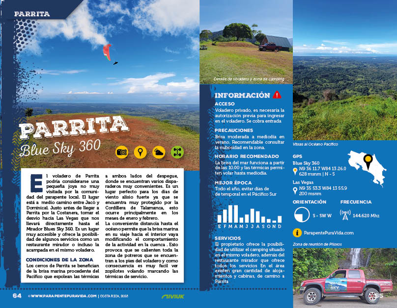
PARRITA (LAS VEGAS)
On the way to Dominical, Parrita is the perfect place to stop along the way.
HOW TO GET THERE
To reach the launch site, head out from La Costanera, take the turnoff toward Las Vegas de Parrita, and continue along the street until you reach the easily recognizable Mirador restaurant, from which a gravel path with a steep incline leads up to the launch terrace.
FLIGHT TERMS AND CONDITIONS
The flight involves thermal soaring along a ridge that’s barely 300 meters high. During the driest months, it becomes a spot where you can gain good altitude if the ceiling is high. It typically provides good dynamic lift all day long.
Landings are private—check with Juan Masis—but be careful of cattle pastures and avoid landing too close to the hillside where the trail up begins, as the terrain forms a wedge and creates a rotor zone.
RATES 2025
– 2,000 colones ONE-WAY flight / day
– 10,000 colones to BIPLAZA / per flight
Luis “owner” (+506 8970 2463) PAYMENT at the restaurant near the takeoff area.
Juan Masis (+506 8345 5703) Please contact him before landing.